GPS with altitude, elevation gain and profile
Every recorded point keeps latitude, longitude and altitude. Elevation gain and loss come from smoothed altitude, because a phone's GPS drifts even when you stand still, and the elevation profile gets a point every 20 m.
- Moving time kept apart from total time, with pauses left out
- If the app closes mid-hike, the recording comes back paused the next time you open it, with every point
- Works for hiking, walking, running and cycling
Name, difficulty and photos
When you finish, name the trail (the app suggests one), pick the difficulty, write a description and attach up to 10 photos. Private and off the feed are the defaults: you decide whether to publish.
- No signal at the end of the trail? It is saved on the phone and sent the next time you open the recorder
- Loop trails recognised when start and finish are less than 200 m apart
- A feed post with your elevation gain, only if you want one
Public trails near you
The catalog lists public trails within 100 km, from nearest to farthest. Filter by distance, elevation gain, difficulty or loops only. No filter is paid.
Elevation profile, weather and GPX
The trail page shows the track, the elevation profile, the stats, the photos, a 7-day forecast at the trailhead and directions to get there. Import a GPX file to create a trail or export any trail to another app.
Follow a trail with an off-route alert
Open a trail and tap Follow: the GPS records over the track and vibrates when you stray more than 50 m from the path. At the end, rate it from 1 to 5 and the trail counts one more completion.
Elevation gain that counts in your group
In groups that score by elevation gain, every metre climbed on a recorded trail is worth one point in the ranking. No estimates: only what the GPS recorded counts.
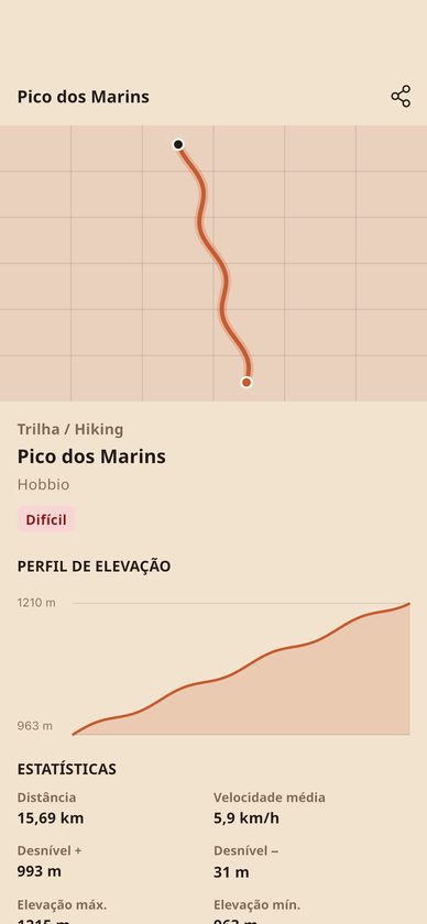
The whole trail in one elevation profile
Every trail shows distance, elevation gain and loss, average speed and the highest and lowest points, with the climb's profile right below the track.
- Difficulty and photos from people who did it
- 7-day forecast at the trailhead
- Import and export GPX
Frequently asked questions
Do I need a watch or any gear?
No. Hobbio only uses your phone's GPS, which keeps recording with the screen locked in your backpack until you finish the hike.
What if there is no signal on the trail?
GPS works without internet. When you save, the trail is stored on the phone before it is sent and uploads once you are back online, the next time you open the recorder.
Can other people see where I live?
Trails start out private. If you publish one, anyone who is not the owner sees the track and the GPX without the first and last 300 m, because a trail may start at your home.
How much does it cost?
Nothing. Recording, saving, searching, following and importing or exporting GPX are free on iPhone and Android.
Lace up your boots and start climbing.
Download Hobbio, open the Hiking hobby and tap record. Free on iPhone and Android.